
A powerful storm system is bearing down on the Pacific Northwest, bringing high winds, heavy rainfall, and hazardous surf conditions across Washington and Oregon, meteorologists warned on Monday, Feb. 24, 2025.
The National Weather Service issued the following “High Wind Warning” at 10:08 a.m. on Monday, warning of expected gusts up to 50-60 mph until Tuesday morning. Residents should secure outdoor furniture and prepare for possible power outages.
High Wind Warning
“URGENT – WEATHER MESSAGE
“National Weather Service Seattle, WA
“10:08 AM PST Mon Feb 24, 2025“HIGH WIND WARNING IN EFFECT UNTIL 10 AM PST TUESDAY
“Affected Areas:
“• Southwest Interior
“• Tacoma Area
“• Lower Chehalis Valley Area
“• Seattle and Vicinity
“• Bremerton and Vicinity“Cities Included: Montesano, Tumwater, Lacey, Seattle, Silverdale, Tacoma, Olympia, Bremerton, McCleary, and Elma.
“Forecast Details:
“• What: South winds 25 to 35 mph, with gusts up to 50 to 60 mph expected.
“• When: Until 10 AM PST Tuesday.“Impacts:
“• Damaging winds may bring down trees and power lines.
“• Widespread power outages are likely.
“• Difficult travel conditions, especially for high-profile vehicles.“Additional Details:
“• Strongest winds are expected overnight Monday into early Tuesday.
“Precautionary/Preparedness Actions:
“• Avoid being outside near trees and branches.
“• If possible, stay in lower levels of your home and away from windows.
“• Use extreme caution if driving, particularly in open areas or in high-profile vehicles.”
According to Michael Snyder of Pacific Northwest Weather Watch, the storm is spinning off the coast, intensifying and moving in, with gusty winds expected to impact both coastal and inland areas.
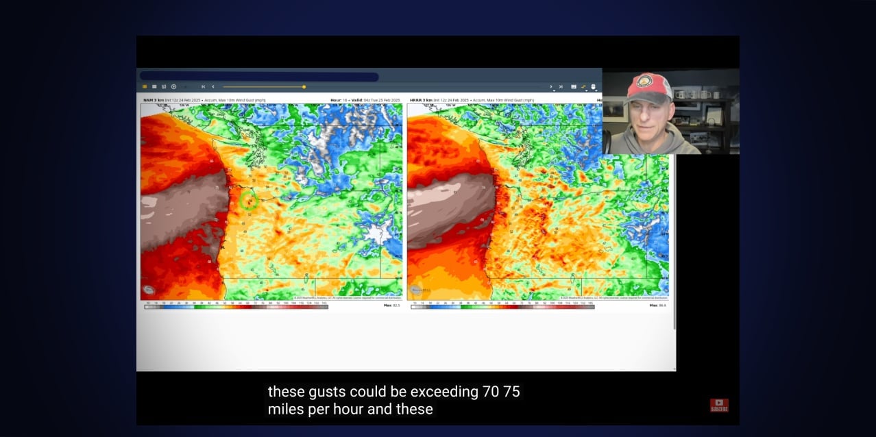
“This is a significant wind event,” Snyder said in a Monday morning video forecast (see below). “Some of these gusts could exceed 70 to 75 miles per hour along the Oregon coast and into Southwest Washington.”
The storm is expected to peak overnight, with the potential for power outages and downed trees due to saturated soils. Wind gusts could reach 50 to 60 mph in the Seattle/Olympia area, while the Oregon coast and Willamette Valley may see gusts up to 50 mph.
Heavy surf is another major concern, with waves reaching 23 to 32 feet along the coasts of Washington and Oregon. Officials urged the public to use extreme caution near beaches.
“This kind of wave action claims lives every year,” Snyder said. “If you’re going out to take photos, bring a buddy and be aware of your surroundings.”
In addition to wind and rain, the storm could produce occasional lightning and even isolated funnel clouds, according to Snyder.
Despite the storm’s intensity, conditions are expected to improve after Tuesday, offering a brief reprieve before another weather system potentially arrives next weekend.
Authorities advised residents to prepare for power outages, secure outdoor objects, and avoid coastal areas during the worst of the storm.
Video Forecast
Below is Snyder’s latest video forecast, released Monday morning, Feb. 24, 2025:
Detailed 7-Day Forecast:
- Monday: Rain. High near 52. Light and variable wind becoming south 8 to 13 mph in the afternoon. Winds could gust as high as 26 mph. Chance of precipitation is 100%. New precipitation amounts between a quarter and half of an inch possible.
- Monday Night: Rain. Low around 45. Breezy, with a south wind 20 to 24 mph, with gusts as high as 40 mph. Chance of precipitation is 100%. New precipitation amounts between a quarter and half of an inch possible.
- Tuesday: Rain, mainly before 4pm. High near 51. Breezy, with a south southwest wind 14 to 22 mph, with gusts as high as 34 mph. Chance of precipitation is 100%. New precipitation amounts of less than a tenth of an inch possible.
- Tuesday Night: A 20 percent chance of rain before 10pm. Mostly cloudy, with a low around 38. Southeast wind 3 to 8 mph.
- Wednesday: Partly sunny, with a high near 59. Light east wind.
- Wednesday Night: A 20 percent chance of rain after 10pm. Mostly cloudy, with a low around 43.
- Thursday: A 50 percent chance of rain. Mostly cloudy, with a high near 56.
- Thursday Night: Mostly cloudy, with a low around 41.
- Friday: Partly sunny, with a high near 56.
- Friday Night: A slight chance of rain after 10pm. Mostly cloudy, with a low around 43.
- Saturday: A chance of rain. Mostly cloudy, with a high near 54.
- Saturday Night: A chance of rain. Mostly cloudy, with a low around 43.
- Sunday: A chance of rain. Mostly cloudy, with a high near 52.
⚠️ Prepare for gusty winds this afternoon through Tuesday morning alongside lowland rain and heavy mountain snow. Winds along the coast could reach 60+ mph, likely to cause power outages, with gusts up to 55 mph elsewhere. #WAwx pic.twitter.com/sr9qLnnPWb
— NWS Seattle (@NWSSeattle) February 24, 2025
High winds and heavy rains are forecasted across the region. Stay safe and be prepared. Keep devices charged and flashlights at the ready. For more tips on preparing for outages, visit: https://t.co/MCBjeVAvp0 pic.twitter.com/bEeRbLkgmP
— Seattle City Light (@SEACityLight) February 24, 2025
41 mph! Power flickering, Normandy Park, WA #wawx pic.twitter.com/QiTmc3QTq5
— Michael Snyder (@SeattleWXGuy) February 24, 2025
A Monster is born… #wawx #orwx #storm #wind #rain pic.twitter.com/HjTVQryoNO
— Michael Snyder (@SeattleWXGuy) February 24, 2025

Recent Comments