
A ‘dynamic storm’ is impacting our region with cold air, snow and rain, as two big weather systems fought it out in the skies above us.
Snow was falling around SeaTac Tuesday morning, Nov. 29, 2022, and depending on elevation or temperature, was either sticking or not sticking to the roads.
Sea-Tac Airport switched into its winter weather operations, removing snow on runways, taxiways and ramps around gates, while airlines brought out their de-icing fluids.
We’re open & winter wx ops continue. It’s a team effort! SEA removes snow on runways, taxiways & ramp areas around gates. Airlines provide de-icing fluids & apply to planes. Check w/ your airline for latest info. Note, 8th floor of parking garage is closed. Thx for your patience! pic.twitter.com/e6JGQoF8pd
— Seattle-Tacoma Intl. Airport (@flySEA) November 29, 2022
Alaska Airlines canceled around 100 flights on Tuesday:
FLIGHT CANCELLATIONS: According to FlightAware, more than 100 flights have been cancelled at Sea-Tac Airport. The vast majority of them are Alaska Airlines flights.
Due to possible snow event, Alaska Airlines has implemented a flexible travel policy: https://t.co/jjxbXfNB2x pic.twitter.com/e5nKbG0VGh
— Steve McCarron KOMO (@SteveTVNews) November 29, 2022
And coming soon – wind! Gusts are expected to reach up to 40mph over the next day or so, and the National Weather Service issued a Wind Advisory:
URGENT – WEATHER MESSAGE
National Weather Service Seattle WA
1110 AM PST Tue Nov 29 2022
…WIND ADVISORY REMAINS IN EFFECT FROM 4 PM THIS AFTERNOON TO 7 AM PST WEDNESDAY…
* WHAT…Southeast winds 20 to 30 mph with gusts up to 40 mph expected.
* WHERE…Everett and Vicinity, Tacoma Area, Bellevue and Vicinity and Seattle and Vicinity.
* WHEN…From 4 PM this afternoon to 7 AM PST Wednesday.
* IMPACTS…Gusty winds could blow around unsecured objects. Tree limbs could be blown down and a few power outages may result.
PRECAUTIONARY/PREPAREDNESS ACTIONS…
Use extra caution when driving, especially if operating a high profile vehicle. Secure outdoor objects.
Local @SeattleWXGuy Michael Snyder released an updated video forecast Tuesday morning, Nov. 29, 2022:
And another as Snyder drove around in the snow:
Join Snyder’s channel to help support Pacific Northwest Weather Watch:
https://www.youtube.com/channel/UCSxR0IZEq1WhTJqAnQGyk4g/join
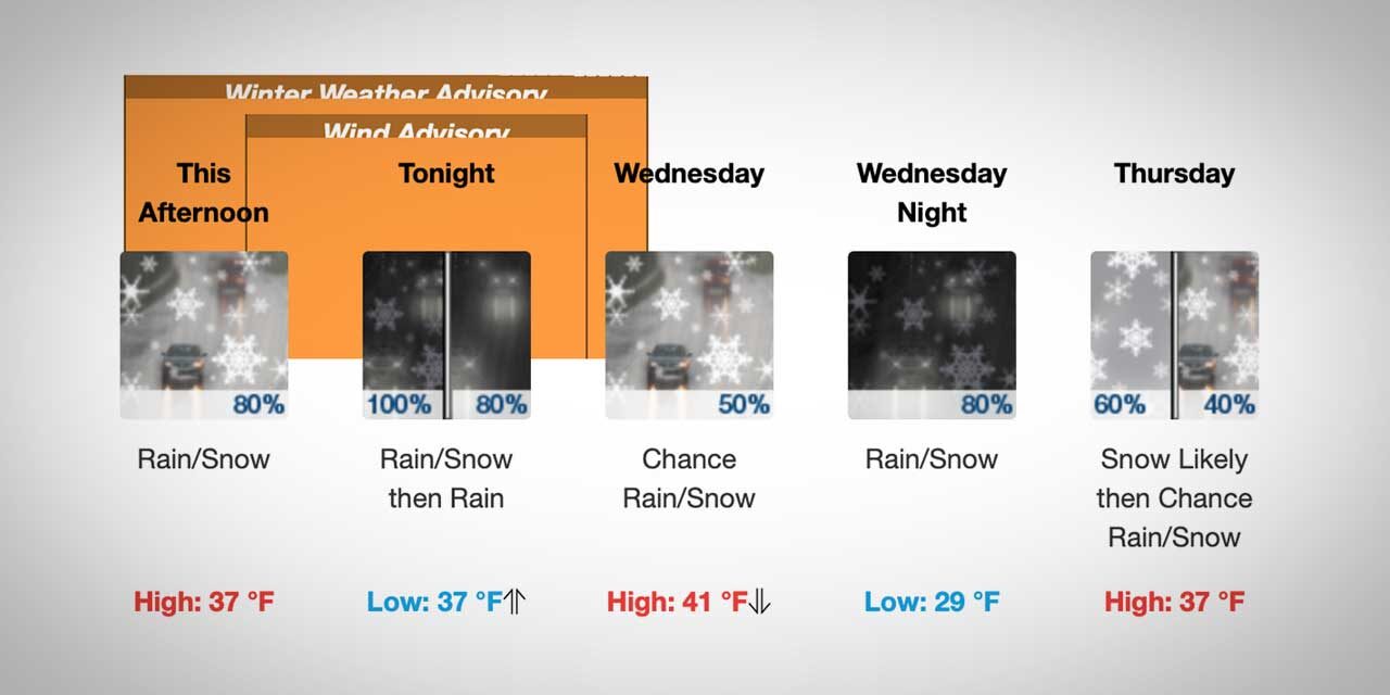
Here’s the latest detailed forecast from the National Weather Service:
- Tuesday: Snow, mainly after 1pm. High near 39. Wind chill values between 25 and 30. Southeast wind 6 to 11 mph. Chance of precipitation is 80%. Total daytime snow accumulation of less than one inch possible.
- Tuesday Night: Rain and snow, becoming all rain after 10pm. Steady temperature around 38. South wind 14 to 18 mph, with gusts as high as 24 mph. Chance of precipitation is 100%. New snow accumulation of less than a half inch possible.
- Wednesday: Rain. Steady temperature around 39. Breezy, with a southwest wind around 22 mph, with gusts as high as 29 mph. Chance of precipitation is 100%. New precipitation amounts between a tenth and quarter of an inch possible.
- Wednesday Night: Rain and snow. Low around 30. Northeast wind 6 to 9 mph. Chance of precipitation is 100%. New snow accumulation of less than a half inch possible.
- Thursday: Snow likely, mainly before 10am. Mostly cloudy, with a high near 37. North northeast wind 8 to 13 mph. Chance of precipitation is 60%. New snow accumulation of less than a half inch possible.
- Thursday Night: A 40 percent chance of snow. Mostly cloudy, with a low around 27. New snow accumulation of less than a half inch possible.
- Friday: Snow likely before 1pm, then rain and snow. High near 39. Chance of precipitation is 80%. New snow accumulation of 1 to 2 inches possible.
- Friday Night: Rain and snow, becoming all rain after 4am. Cloudy, with a low around 34.
- Saturday: A chance of rain and snow before 1pm, then a chance of rain between 1pm and 4pm, then a slight chance of rain and snow after 4pm. Mostly cloudy, with a high near 39.
- Saturday Night: A slight chance of rain and snow before 10pm. Mostly cloudy, with a low around 29.
- Sunday: A slight chance of rain and snow. Partly sunny, with a high near 39.
- Sunday Night: A chance of rain and snow. Mostly cloudy, with a low around 31.
- Monday: A chance of rain and snow. Partly sunny, with a high near 39.
Dynamic storm impacting the Pacific NW! https://t.co/sutigccxRf via @YouTube pic.twitter.com/DQ7mQASDOZ
— Michael Snyder (@SeattleWXGuy) November 29, 2022
It’s treacherous out here, especially on the back roads #wawx pic.twitter.com/VpJ1DIPmql
— Michael Snyder (@SeattleWXGuy) November 29, 2022
#snow is sticking #wawx pic.twitter.com/6hD6qNgZdX
— Michael Snyder (@SeattleWXGuy) November 29, 2022
#snow #wawx #video pic.twitter.com/uydc4U3yep
— Michael Snyder (@SeattleWXGuy) November 29, 2022

Recent Comments